Translate

Thursday 30 July 2015

BIKANER


Information from Wikipedia:

  1. Bikaner is a city in the northwest of the state of Rajasthan in northern India. It is located 330 kilometres northwest of the state capital, Jaipur. Bikaner city is the administrative headquarters of Bikaner District and Bikaner division. Wikipedia
  2. Area10,991 mi² (28,466 km²)
  3. Weather78°F (26°C), Wind SW at 5 mph (8 km/h), 96% Humidity
  4. Hotels3-star averaging $30. View hotels
  5. Local timeThursday 10:10 PM

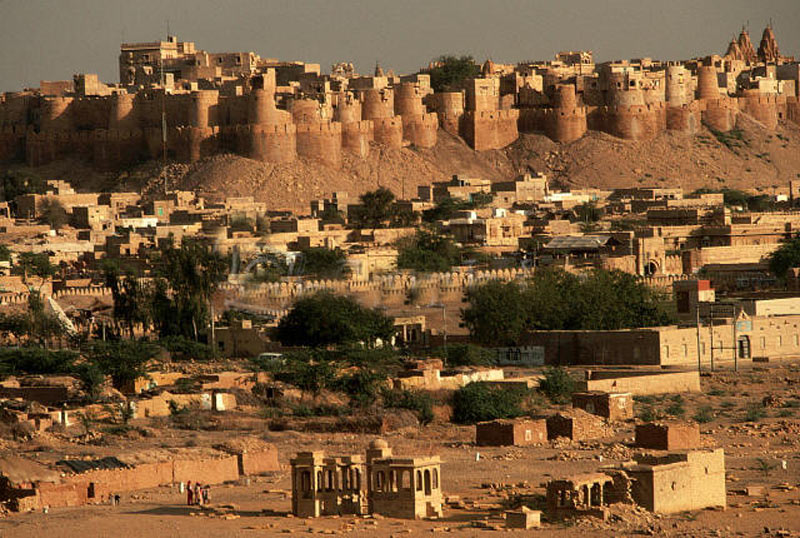
Prior to the mid 15th century, the region that is now Bikaner was a barren wilderness called Jangladesh.[4] In 1488 Rao Bika established the city of Bikaner. According to James Tod, the spot which Bika selected for his capital, was the birthright of a Nehra Jat, who would only concede it for this purpose on the condition that his name should be linked in perpetuity with its surrender. Naira, or Nera, was the name of the proprietor, which Bika added to his own, thus composing that of the future capital, Bikaner. Rao Bika was the first son of Maharaja Rao Jodha of the Rathor clan, the founder of Jodhpur and conquered the largely arid country in the north of Rajasthan. As the first son of Jodha he wanted to have his own kindom not inheriting Jodhpur from his father or the title of Maharaja. He therefore decided to build his own kingdom in what is now the state of Bikaner in the area of Jungladesh. Though it was in the Thar Desert, Bikaner was considered an oasis on the trade route between Central Asia and theGujarat coast as it had adequate spring water. Bika’s name was attached to the city he built and to the state of Bikaner ("the settlement of Bika") that he established. Bika built a fort in 1478, which is now in ruins, and a hundred years later a new fort was built about 1.5 km from the city centre, known as the Junagarh Fort.
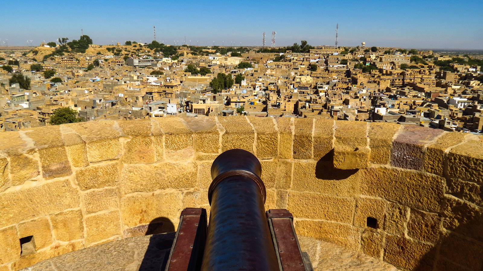
Around a century after Rao Bika founded Bikaner, the state's fortunes flourished under the sixth Raja, Rai Singhji, who ruled from 1571 to 1611. During the Mughal Empire’s rule in the country, Raja Rai Singh accepted the suzerainty of the Mughals and held a high rank as an army general at the court of the Emperor Akbar and his son the Emperor Jahangir. Rai Singh's successful military exploits, which involved winning half of Mewar kingdom for the Empire, won him accolades and rewards from the Mughal emperors. He was given the jagirs (lands) of Gujarat and Burhanpur. With the large revenue earned from these jagirs, he built the Chintamani durg (Junagarh fort) on a plain which has an average elevation of 760 feet (230 m). He was an expert in arts and architecture, and the knowledge he acquired during his visits abroad is amply reflected in the numerous monuments he built at the Junagarh fort.
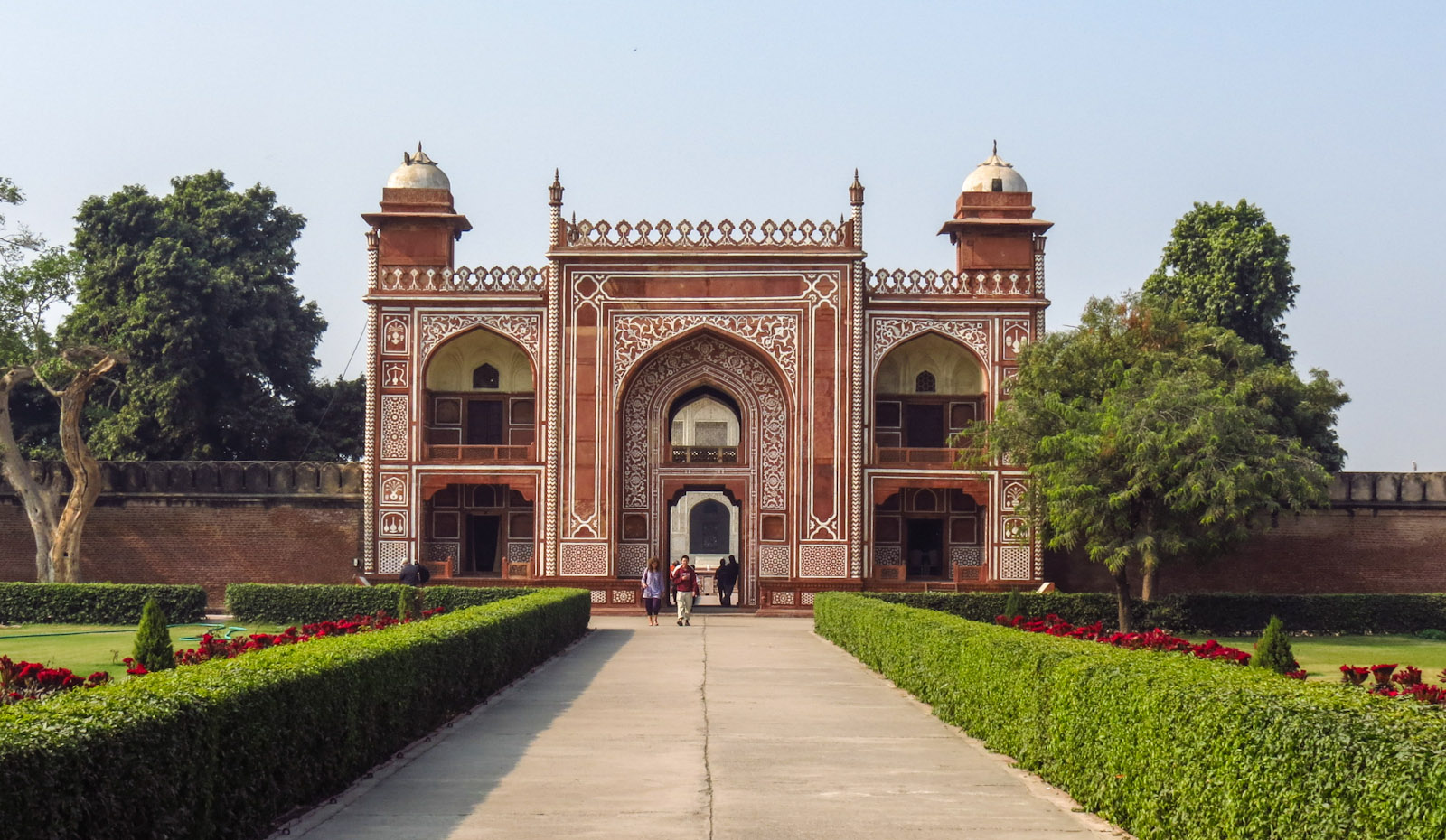
Maharaja Karan Singh, who ruled from 1631 to 1639, under the suzerainty of the Mughals, built the Karan Mahal palace. Later rulers added more floors and decorations to this Mahal. Anup Singh ji, who ruled from 1669 to 1698, made substantial additions to the fort complex, with new palaces and the Zenana quarter, a royal dwelling for wommen and children. He refurbished the Karan Mahal with a Diwan-i-Am (public audience hall) and called it the Anup Mahal.Maharaja Gaj Singh, who ruled from 1746 to 1787 refurbished the Chandra Mahal (the Moon palace).
During the 18th century, there was internecine war between the rulers of Bikaner and Jodhpur and also amongst other thakurs, which was put down by British troops.
Following Maharaja Gaj Singh, Maharaja Surat Singh ruled from 1787 to 1828 and lavishly decorated the audience hall (see illustration) with glass and lively paintwork. Under atreaty of paramountcy signed in 1818, during Maharaja Surat Singh's reign, Bikaner came under the suzerainty of the British, after which the Maharajas of Bikaner invested heavily in refurbishing Junagarh fort.
Left: Lalgarh Palace, built (Indo-Saracenic style) for Maharaja Ganga Singh and named after his father, presently a heritage hotel and also a residence of theBikaner Royal Family. Right: Ganga Singh as a member of the Imperial War Cabinet at No. 10 Downing Street, 1917.
Dungar Singh, who reigned from 1872 to 1887, built the Badal Mahal, the 'weather palace', so named in view of a painting of clouds and falling rain, a rare event in arid Bikaner.
General Maharaja Ganga Singh, who ruled from 1887 to 1943, was the best-known of the Rajasthan princes and was a favourite of the British Viceroys of India. He was appointed a Knight Commander of the Order of the Star of India, served as a member of the Imperial War Cabinet, represented India at the Imperial Conferences during the First World War and the British Empire at the Versailles Peace Conference. His contribution to the building activity in Junagarh involved separate halls for public and private audiences in the Ganga Mahal and a durbar hall for formal functions. He also built the Ganga Niwas Palace, which has towers at the entrance patio. This palace was designed by Sir Samuel Swinton Jacob, the third of the new palaces built in Bikaner. He named the building Lalgarh Palace in honour of his father and moved his main residence there from Junagarh Fort in 1902. The hall where he held his Golden Jubilee (in 1938) as Bikaner's ruler is now a museum.
Ganga Singh's son, Lieutenant-General Sir Sadul Singh, the Yuvaraja of Bikaner, succeeded his father as Maharaja in 1943, but acceded his state to the Union of India in 1949. Maharaja Sadul Singh died in 1950, being succeeded in the title by his son, Karni Singh (1924-1988).[6] The Royal Family still lives in a suite in Lalgarh Palace, which they have converted into a heritage hotel.

Image from Google image:  


JAISALMER


Information from Wikipedia:

Jaisalmer, nicknamed "The Golden city", is a city in the Indian state of Rajasthan. It is located 575 km west of the state capital Jaipur. It is a World Heritage Site. It was once known as Jaisalmer state.
Jaisalmer is named after Maharawal Jaisal Singh, a Rajput king who founded the city in 1156 AD.[1] "Jaisalmer" means "the Hill Fort of Jaisal". Jaisalmer is sometimes called the "Golden City of India" because the yellow sand and the yellow sandstone used in every architecture of the city gives a yellowish-golden tinge to the city and its surrounding area.
Jaisalmer District is located within a rectangle lying between 26°.4’–28°.23' North parallel and 69°.20'–72°.42' east meridians. It is the largest district of Rajasthan and one of the largest in the country. The breadth (East-West) of the district is 270 km (170 mi) and the length (North-South) is 186 km (116 mi). On the present map, district Jaisalmer is bounded on the north by Bikaner, on the west & south-west by the Pakistani border, on the south by Barmer and Jodhpur, and on the east by Jodhpur and Bikaner Districts. The length of international border attached to Jaisalmer District is 471 km (293 mi).
he majority of the inhabitants of Jaisalmer are Bhati Rajputs, named for Bhati, who was renowned as a warrior. The ruling family of the erstwhile Jaisalmer State belongs to Bhati Clan of Yadu[2] Rajputs of Chandravanshi (Lunar) race who claim descent from Lord Krishna,the deified hero who ruled at Dwarka.[3] In 1156 Rawal Jaisal,[1] the sixth in succession from Deoraj, founded the fort and city of Jaisalmer,atop Trikuta Hill and began to levy taxes on the camel caravans travelling along the nearby route. Laden with exotic spices and precious silks, these trading caravans were en route to cities like Delhi or Sind, but had to pass directly through Jaisalmer. This strategic location continued to serve Jaisalmer well, as it lay right on the two main routes connecting India with Persia, Egypt and farther west. He later made it his capital as he moved from his former capital at Lodhruva (which is situated about 15 km (9.3 mi) to the north-west of Jaisalmer). In 1293, the Bhattis so enraged the Sultan of Delhi Ala-ud-din Khilji that his army captured and sacked the fort and city of Jaisalmer, so that for some time it was quite deserted.Some Bhatti's from the Royal family migrated to Jaisal (Now in Pakistan), a place near to Chiniot Distt and some migrated to Talwandi, now Nankana Sahib in Distt. Nankana Sahib (Punjab, Pakistan) and others settled in Larkana (in Sind, Pakistan)under the name of Bhutto. In Nankana Sahib, the Bhatti Clan can be traced from the lineage of Rai Bhoe and Rai Bular Bhatti. After this there is nothing to record until the time of Rawal Sahal Singh, whose reign marks an epoch in Jaisalmer's history in that he acknowledged the supremacy of the Mughal emperor Shah Jahan. Following the collapse of the Mughal Empire in the 18th century, Jaisalmer, like the rest of Rajputana, became subservient to theMarathas,[4] until it came under the protection of the British East India Company following the British victory in the Third Anglo-Maratha War. In 1818, the Rawals of Jaisalmer signed a treaty with the British, which protected Jaisalmer from invasion provided it was not the aggressor and guaranteed the royal succession.
The Maharajas of Jaisalmer trace their lineage back to Jaitsimha, a ruler of the Bhati Rajput clan. The major opponents of the Bhati Rajputs were the powerful Rathor clans ofJodhpur and Bikaner. They used to fight battles for the possession of fortswaterholes or cattle. Jaisalmer was positioned strategically and was a halting point along a traditional trade route traversed by the camel caravans of Indian and foreign merchants. The route linked India to Central Asia, EgyptArabiaPersiaAfrica and the West.

Image from Google image: 


Tuesday 28 July 2015

AGRA


    Information from Wikipedia:
  1. Agra, a city in northern India’s Uttar Pradesh state, is home to the iconic Taj Mahal, a mausoleum built for the Mughal ruler Shah Jahan’s wife, Mumtaz Mahal, who died in childbirth in 1631. Set behind a reflecting pool inside a courtyard defined by 4 minarets, the imposing main building features a massive dome and intricately carved white marble inlaid with precious stones.
  2. Area72.74 mi² (188.4 km²)
  3. Hotels3-star averaging $30, 5-star averaging $80. View hotels
  4. Weather80°F (27°C), Wind S at 9 mph (14 km/h), 75% Humidity
  5. Local timeTuesday 11:40 PM

Though Agra's history is largely recognised with Mughal Empire, the place was established much before it and has linkages since Mahabharat period and Mahirshi Angira in 1000 BC.[citation needed] It is generally accepted that Sultan Sikandar Lodī, the Ruler of theDelhi Sultanate founded Agra in the year 1504. After the Sultan's death the city passed on to his son Sultan Ibrāhīm Lodī. He ruled his Sultanate from Agra until he fell fighting to Bābar in the First battle of Panipat fought in 1526.
The Red fort, Agra, c. 1820
The golden age of the city began with the Mughals. It was known then as Akbarabād and remained the capital of the Mughal Empire under the Emperors AkbarJahāngīr and Shāh JahānShāh Jahān later shifted his capital to Shāhjahānabād in the year 1689.
Since Akbarabād was one of the most important cities in India under the Mughals, it witnessed a lot of building activity. Babar, the founder of the Mughal dynasty, laid out the first formal Persian garden on the banks of river Yamuna. The garden is called the Arām Bāgh or the Garden of Relaxation. His grandson Akbar raised the towering ramparts of the Great Red Fort, besides making Agra a center for learning, arts, commerce and religion. Akbar also built a new city on the outskirts of Akbarabād called Fatehpūr Sikrī. This city was built in the form of a Mughal military camp in stone.
His son Jahāngīr had a love of gardens and flora and fauna and laid many gardens inside the Red Fort or Lāl Qil'a. Shāh Jahān, known for his keen interest in architecture, gave Akbarabād its most prized monument, the Tāj Mahal. Built in loving memory of his wife Mumtāz Mahal, the mausoleum was completed in 1653.
Shāh Jahān later shifted the capital to Delhi during his reign, but his son Aurangzeb moved the capital back to Akbarabād, usurping his father and imprisoning him in the Fort there. Akbarabād remained the capital of India during the rule of Aurangzeb until he shifted it to Aurangabad in the Deccan in 1653. After the decline of the Mughal Empire, the city came under the influence of Marathas and was called Agra, before falling into the hands of the British Raj in 1803.
Agra, Main Street, c.1858
In 1835 when the Presidency of Agra was established by the British, the city became the seat of government, and just two years later it was witness to the Agra famine of 1837–38. During the Indian rebellion of 1857 British rule across India was threatened, news of the rebellion had reached Agra on 11 May and on 30 May two companies of native infantry, the 44th and 67th regiments, rebelled and marched to Delhi. The next morning native Indian troops in Agra were forced to disarm, on 15 June Gwalior (which lies south of Agra) rebelled. By 3 July the British were forced to withdraw into the fort. Two days later a small British force at Sucheta were defeated and forced to withdraw, this led to a mob sacking the city. However, the rebels moved onto Delhi which allowed the British to restore order by 8 July. Delhi fell to the British in September, the following month rebels who had fled Delhi along with rebels from Central India marched on Agra but were defeated. After this British rule was again secured over the city until the independence of India in 1947.
Agra is the birthplace of the religion known as Dīn-i Ilāhī, which flourished during the reign of Akbar and also of the Radhaswami Faith, which has around two million followers worldwide. Agra has historic linkages with Shauripur of Jainism and Runukta of Hinduism, of 1000 BC.
Taj Mahal, Agra Fort and Fatehpur Sikri are all UNESCO World Heritage Sites

Image from Google image:


AJMER

  1. Information from Wikipedia:

  2. Ajmer is the 5th largest city in Rajasthan and is the centre of the eponymous Ajmer District. Ajmer has a population of around 551,360 in its urban agglomeration and 542,580 for the city, and is located ...
  3. Hotels3-star averaging $30. View hotels
  4. Weather73°F (23°C), Wind S at 15 mph (24 km/h), 94% Humidity
  5. Local timeTuesday 11:17 PM


According to Rajputana Gazetteer, Ajmer was held by Chechi Gurjars until about 700 years ago. Ajmer (Sanskrit अजय-मेरु Ajayameru meaning "Invincible Mountain") was founded in the late 7th century A.D. by Ajayraj Singh Chauhan. Chauhan clan is a branch of Chechi Gurjars. The Chauhan dynasty ruled Ajmer in spite of repeated invasions by Turkic Muslim armies from Central Asia across the north of India. Ajmer was conquered by Muhammad of Ghor, founder of the Delhi Sultanate, in 1193. However, the Chauhan rulers were able to gain autonomy upon the payment of a heavy tribute to him. Ajmer regained independence under the ruler of Mewar in 1365. In 1509, control of Ajmer was disputed between the Maharajas of Mewar and Marwar unitil it was conquered by the Marwar in 1532. In 1553, the state was ruled by the Hindu Emperor Hem Chandra Vikramaditya, popularly known as Hemu, who was killed in 1556 in the Second Battle of Panipat. The city was conquered by the Mughal emperor Akbar in 1559. In the early 1700s century, control passed to the Marathas.
In 1818 the British forced the Marathas to cede the city for 50,000 rupees whereupon it became part of the province of Ajmer-Marwar, which consisted of the districts of Ajmer and Merwara and were physically separated by the territory of the Rajputana Agency. Ajmer-Marwar was directly administered by the British Raj, by a commissioner who was subordinate to the Governor-General's agent for Rajputana. Ajmer-Marwar remained a province of India until 1950, when it became the Ajmer State.
Ajmer state became part of Rajasthan state on 1 November 1956.
Ajmer is surrounded by the Aravalli Mountains. The city is sied on the lower slopes of the Taragarh Hill in the Aravalli Range. It is situated almost in the centre of Rajasthan. To the north of the city is a large artificial lake, called Anasagar with a marble structure known as Baradari. Ajmer is protected from the Thar desert by the massive rocks of Nagpathar range.
Ajmer is also antipodal to the Chilean remote island of Isla Sala y Gómez.

Image from Google image: